

The hidden network of Welsh drovers’ roads
Long before modern motorways and railways reshaped the British landscape, Wales was crossed by a web of ancient drovers’ roads. These long-distance routes, worn into the hills by the hooves of thousands of cattle and sheep, once formed the backbone of rural commerce. From the rugged uplands of Ceredigion and Snowdonia to the bustling markets of London and the English Midlands, Welsh drovers walked for weeks, driving livestock along these green corridors of trade, culture, and exchange.
Today, many of these drovers’ roads survive as quiet lanes, grassy bridleways, and moorland tracks. For visitors interested in walking, cycling, or exploring Welsh history, they offer a distinctive way to understand how a largely pastoral economy sustained itself for centuries. They are not simply old paths: they are living traces of a vanished world of seasonal movement, local ingenuity, and cross-border connection.
What were the Welsh drovers’ roads?
Drovers’ roads were long-distance drove routes used to move cattle, sheep, pigs, and even geese from remote Welsh farms to major markets and fairs in England and Wales. For centuries, particularly from the late medieval period through the 18th and early 19th centuries, these routes functioned as commercial arteries. They enabled Welsh farmers to reach buyers far beyond their localities and ensured a regular supply of meat and wool to rapidly growing English towns.
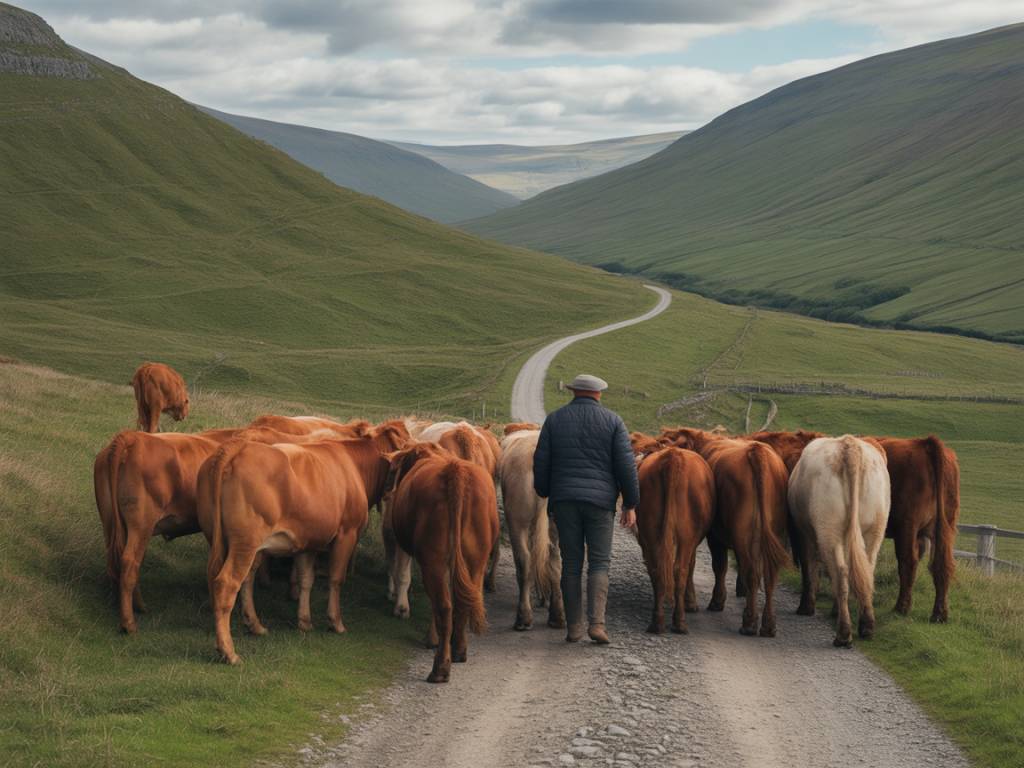
Welsh drovers specialised in long-haul movement of livestock. A single drover could manage hundreds of animals, sometimes with the help of dogs and a small team. The journeys were slow – often covering no more than 15–20 kilometres per day – and carefully planned around grazing, water sources, overnight stops, and toll gates. Over time, preferred routes became established, reinforced by legal rights of way, customary use, and investment in infrastructure such as fords, bridges, and inns.
In a region characterised by mountains, bogs, and isolated valleys, drovers’ roads represented navigable, semi-formalised corridors that were both practical and relatively safe. Their alignment, often following ridgelines and open common land, was designed to keep large herds away from cultivated fields, while still connecting key settlements and crossing points.
The economic lifeline of rural Wales
The history of drovers’ roads in Wales is closely tied to the evolution of the rural economy. For many upland communities, cattle and sheep were not simply agricultural products; they were portable assets and a form of currency. The drove trade allowed farmers to convert their animals into cash in distant markets where prices were higher and demand more stable.
Large cattle fairs, such as those at Builth Wells, Tregaron, Llandovery, and Dolgellau, functioned as important hubs in this network. Drovers would gather livestock from surrounding districts, negotiate bulk purchases, and then move onward in organised groups along recognised drovers’ routes. From central Wales, the herds might be driven east across the border into Herefordshire and the Midlands, or south and east towards London’s Smithfield Market.
This system had a significant impact on the Welsh landscape. It stimulated the growth of market towns, drovers’ inns, and banking services. Some historians argue that the drovers’ trade contributed to the early development of rural finance, as trusted drovers began carrying money, letters of credit, and notes on behalf of local gentry and merchants. The drover’s reputation for honesty and reliability was essential: in a largely cashless and contract-light environment, trust was a critical form of capital.
Routes across mountains, moors, and borders
Because droving depended on open space and accessible terrain, Welsh drovers’ roads tended to avoid narrow valleys and heavily cultivated land. Instead, they used higher ground, ridgeways, and commons where large herds could move with minimal damage to crops. This preference is why so many former drovers’ routes now appeal to hikers and long-distance walkers: they often combine expansive views with relatively gentle gradients.
Some of the most significant historical routes included:
- The Cambrian drovers’ routes from Ceredigion and Carmarthenshire eastwards through central Wales, converging on Builth Wells, Rhayader, and Llandovery before crossing into England.
- The northern routes from Anglesey and the Llŷn Peninsula via Conwy, Bala, and Corwen, linking north-west Wales with English markets in Cheshire and beyond.
- The Tregaron to Abergwesyn and Beacons routes, climbing over remote passes and later overlapping with what is now known as the Cambrian Mountains region.
At key river crossings, bridges were fortified or tolls charged, creating focal points in the network. Patterns of place names – “Bullock Lane”, “Drove Road”, and Welsh names incorporating “heol” (road) and “y drofa” (associated with droving) – preserve the memory of these routes even where the physical track has faded.
Everyday life on the drove
The romanticised image of the drover as a solitary figure in the mist hides a complex social and logistical reality. Droving was hard, repetitive work that demanded detailed knowledge of animal behaviour, weather patterns, and local geography. The drover also needed negotiation skills for dealing with landowners, gatekeepers, and market traders.
A typical day on a Welsh drovers’ road began early. The herd would be gathered and checked, then moved off at a steady walking pace, allowing the animals to graze along verges and commons. The group had to be kept together but not hurried; overdriving could cause weight loss and injuries, reducing the animals’ value on arrival. Rest stops were carefully placed: near streams, on open common land, or at recognised “stance” fields where a fee was paid to use enclosed pasture overnight.
Drovers frequently used specialised equipment: sturdy sticks, leather gaiters, cloaks or greatcoats for bad weather, and often distinctive hats. Many travelled with trained dogs, whose ability to move and control the herd was vital. Inns and taverns along drovers’ roads became informal networks of information and support, offering stabling, fodder, and gossip about prices and demand in distant markets.
For local communities, the arrival of a drove could be both disruption and opportunity. Roads filled with animals; fields near the route might be rented out for resting herds; and local producers could sell food and drink to the drovers. The seasonal rhythm of droving introduced an element of mobility and external contact into rural life that is sometimes overlooked in narratives of “isolated” Welsh upland communities.
Cultural exchange and the shaping of Welsh identity
Beyond economics, the drovers’ roads of Wales were channels of cultural exchange. Drovers carried more than livestock; they brought news, stories, songs, and innovations back and forth between Welsh villages and English towns. In this sense, the drovers served as informal messengers and cultural intermediaries.
The Welsh language, spoken throughout much of rural Wales, was heard and sometimes learned in English market towns along the routes. At the same time, English legal and commercial practices filtered back into Welsh communities, influencing local governance, land management, and business methods. The figure of the drover appears in Welsh literature, folklore, and song as both a symbol of independence and a reminder of economic dependence on external markets.
Some drovers’ families grew prosperous, investing their earnings in land, inns, or local businesses. Others remained itinerant, their lives shaped by the uncertainties of weather, market prices, and animal health. Yet across these variations, droving contributed to a sense of Wales as a connected region whose uplands were not peripheral but actively integrated into wider British patterns of trade.
The decline of droving and the survival of the roads
The heyday of Welsh drovers’ roads began to fade in the 19th century. Several factors combined to undermine the traditional system:
- Enclosure and land reform reduced access to common grazing and disrupted established routes.
- Improved roads and canals changed patterns of transport and made some droveways obsolete.
- The coming of the railways offered faster, less labour-intensive ways to move livestock to urban markets.
- Shifts in agricultural practice, including new breeds and feeding methods, altered the economics of long-distance droving.
By the late 19th century, many former drovers had become livestock dealers, carriers, or farmers using rail transport. Yet the physical traces of their routes never disappeared completely. In rural Wales, where field systems and rights of way often have deep historical roots, many drovers’ roads survived as unfenced lanes, byways, or trackways across open moorland.
In the 20th and 21st centuries, interest in heritage tourism, walking, and cycling has drawn attention back to these routes. Long-distance paths, such as sections of the Glyndŵr’s Way National Trail and various regional trails in Powys, Ceredigion, and Gwynedd, deliberately follow or intersect with ancient droving paths. Conservation bodies and local history groups have undertaken research to map, interpret, and signpost routes that might otherwise be lost to memory.
Exploring Welsh drovers’ roads today
For travellers seeking an alternative way to experience Wales, exploring the historic drovers’ roads offers a blend of landscape, heritage, and quiet adventure. Unlike some of the more famous national trails, many drovers’ routes remain relatively uncrowded, passing through working farmland and small communities rather than major tourist centres.
Key areas for discovering drovers’ roads include:
- The Cambrian Mountains, where open moorland tracks and remote passes echo centuries of seasonal movement between west Wales and the borderlands.
- Mid Wales (Powys and Ceredigion), whose market towns such as Builth Wells, Rhayader, and Tregaron retain physical and narrative links to the drove trade.
- North Wales, particularly around Bala, Dolgellau, and Corwen, where upland drovers’ paths intersect with ancient routes through Snowdonia and the Clwydian hills.
Many former drovers’ roads are now public rights of way, suitable for walking, horse riding, or cycling. Others cross private land and require respect for current agricultural use. Detailed Ordnance Survey maps, local guidebooks, and heritage trail leaflets can help identify surviving segments and plan responsible visits.
For those interested in cultural tourism, combining walks along drovers’ roads with visits to local museums, churches, and historic inns can deepen the experience. Interpretive panels, community heritage projects, and oral histories often highlight specific sites: old stance fields where herds rested, former tollhouses, or inns that once rang with the voices of drovers haggling over prices.
Why the drovers’ roads of Wales matter
The ancient drovers’ roads of Wales are more than picturesque relics. They provide insight into how a rural, largely pastoral economy functioned at scale, linking remote uplands to national markets long before modern infrastructure. They reveal a pattern of movement that cut across linguistic, cultural, and regional boundaries, helping to shape both Welsh identity and the wider British economy.
For contemporary visitors and researchers, these routes offer an unusual combination of tangible and intangible heritage. The physical pathway is still there underfoot – a hollow way through a hedge, a green lane skirting a hillside, a track fading into open moor. At the same time, the stories, skills, and social networks that sustained droving invite reflection on mobility, adaptation, and resilience in rural societies.
Walking a section of a Welsh drovers’ road today is to step into a landscape layered with the traces of cattle, culture, and commerce. It connects the quiet rhythms of present-day countryside life with the once-bustling traffic of animals and people who, over centuries, carved these pathways across the heart of Wales.